NOAA Storm Prediction Center

Saturday 16 July 2011

Lightning and Thunder

This is a continuation from my previous blog on Charge Generation in Thunderstorms.


As electrical charges are separated in a cloud, the electric field intensity increases and eventually exceeds that which the air can sustain. The resulting dielectric breakdown assumes the form of a lightning flash that can be either (1) within the cloud itself, between clouds, or from the cloud to the air (which we will call cloud flashes) or (2) between the cloud and the ground (a ground flash).


Ground flashes that charge the ground negatively originate from the lower main negative charge center in the form of a discharge, called the stepped leader, which moves downward toward the Earth in discrete steps. Each step lasts for about 1 µs, during which time the stepped leader advances about 50 m; the time interval between steps is about 50 µs. It is believed that the stepped leader is initiated by a local discharge between the small pocket of positive charge at the base of a thundercloud and the lower part of the negatively charged region (see image below). This discharge releases electrons that were previously attached to precipitation particles in the negatively charged region. These free electrons neutralize the small pocket of positive charge that may be present below the main charging zone and then move toward the ground. As the negatively charged stepped leader approaches the ground, it induces positive charges on the ground, especially on protruding objects, and when it is 10-100 m from the ground, a discharge moves up from the ground to meet it. After contact is made between the stepped leader and the upward connecting discharge, large numbers of electrons flow to the ground and a highly luminous and visible lightning stroke propagates upward in a continuous fashion from the ground to the cloud along the path followed by the stepped leader. This flow of electrons (called the return stroke) is responsible for the bright channel of light that is observed as a lightning stroke. Because the stroke moves upward so quickly (in about 100 µs), the whole return stroke channel appears to the eye to brighten simultaneously.


Lightning Flash Animation. (Stepped Leader, Return Stroke, and Dart Leader)

After the downward flow of electrons, both the return stroke and the ground, to which it is linked, remain positively charged in response to the remainder of the negative charge in the main charging zone. Following the first stroke, which typically carries the largest current (average 30,000 A), subsequent strokes can occur along the same main channel, provided that additional electrons are supplied to the top of the previous stroke within about 0.1 s of the cessation of current. The additional electrons are supplied to the channel by so-called K or J streamers, which connect the top of the previous stroke to progressively more distant regions of the negatively charged area of the cloud . A negatively charged leader, called the dart leader, then moves continuously downward to the Earth along the main path of the first-stroke channel and deposits further electrons on the ground. The dart leader is followed by another visible return stroke to the cloud. The first stroke of a flash generally has many downward- directed branches because the stepped leader is strongly branched; subsequent strokes usually show no branching, because they follow only the main channel of the first stroke. Most lightning flashes contain three or four strokes, separated in time by about 50 ms, which can remove 20 coulomb or more of charge from the lower region of a thundercloud. The charge-generating mechanisms within the cloud must then refurbish the charge before another stroke can occur. This they can do in as little as 10 s.


In contrast to the lightning flashes described earlier, most flashes to mountain tops and tall buildings are initiated by stepped leaders that start near the top of the building, move upward, and branch toward the base of a cloud. Lightning rods protect tall structures from damage by routing the strokes to the ground through the rod and down conductors rather than through the structure itself.

                                (a)                                                              (b)
(a) A time exposure of a ground lightning flash that was initiated by a stepped leader that propagated from the cloud to the ground. Note the downward-directed branches that were produced by the branched stepped leader.
(b) A time exposure of a lightning flash from a tower on a mountain to a cloud above the tower. This flash was initiated by a stepped leader that started from the tower and propagated upward to the cloud. In contrast to (a), note the upward-directed branching in (b).

A lightning discharge within a cloud generally neutralizes the main positive and negative charge centers. Instead of consisting of several discrete strokes, such a discharge generally consists of a single, slowly moving spark or leader that travels between the positively and the negatively charged regions in a few tenths of a second. This current produces a low but continuous luminosity in the cloud upon which may be superimposed several brighter pulses, each lasting about 1 ms. Tropical thunderstorms produce about 10 cloud discharges for every ground discharge, but in temperate latitudes the frequencies of the two types of discharge are similar. The return stroke of a lightning flash raises the temperature of the channel of air through which it passes to above 30,000 K in such a short time that the air has no time to expand. Therefore, the pressure in the channel increases almost instantaneously to 10-100 atm. The high-pressure channel then expands rapidly into the surrounding air and creates a very powerful shock wave (which travels faster than the speed of sound) and, farther out, a sound wave that is heard as thunder. Thunder is also produced by stepped and dart leaders, but it is much weaker than that from return strokes. Thunder generally cannot be heard more than 25 km from a lightning discharge. At greater distances the thunder passes over an observer’s head because it is generally refracted upward due to the decrease of temperature with height.

Although most ground lightning flashes carry negative charge to the ground, about 10% of the lightning flashes in mid-latitude thunderstorms carry a positive charge to the ground. Moreover, these flashes carry the largest peak currents and charge transfers. Such flashes may originate from the horizontal displacement by wind shear of positive charge in the upper regions of a thunderstorm or, in some cases, from the main charge centers in a thunderstorm being inverted from normal.

Wednesday 13 July 2011

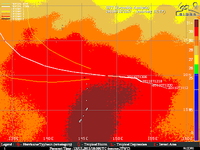
Typhoon Ma-On A Possible Threat to Japan

Check this article out from accuweather.com: Typhoon Ma-On a Threat To Japan

Visible Satellite (1km)


Enhanced Infrared Satellite


Sea Surface Temperature (SST)


NOAA HYSPLIT MODEL of forward trajectories.

Monday 11 July 2011

Charge Generation in Thunderstorms

Hello Everyone!
Today's blog is about a weather phenomenon we observe quite a lot during the summer months, and yet it is something that we don't fully understand. This weather phenomenon is lighting. But before lighting can occur, a mechanism  is needed to produce the charge buildup to electrify a thundercloud. 


All clouds are electrified to some degree.The distribution of charges in thunderstorms has been investigated with special radiosondes (called altielectrographs), by measuring the changes in the electric field at the ground that accompany lightning flashes, and with instrumented aircraft's. These studies have shown that, on average, thunderstorms contain positive charges in their upper regions, negative charges lower down but above the 0 degree C isotherm, and a much smaller pocket of positive charges just below the melting point.

     Schematic diagram to show the distribution of charges in a thunderstorm.


The magnitudes of the lower negative charge and the upper positive charge are approx. 10 –100 coulombs (hereafter symbol “C). The location of the negative charge (called the main charging zone) is rather well defined between the -10 degree C and about -20 degree C temperature levels. The positive charge is distributed in a more diffuse region above the negative charge. Although there have been a few reports of lightning from warm clouds, the vast majority of thunderstorms occur in cold clouds.

In order to understand the theories of thunderstorm electrification, I will first give a brief explanation of what the thermoelectric effect in ice is.  Let us consider a rod of ice warmed at one end and cooled at the other, so that a steady temperature difference ΔT is maintained between its two ends. Some of the water molecules in ice are always dissociated into positive and negative ions and the number of these ions is greater at higher temperatures. Therefore, the warmer end of the ice rod will contain more positive and negative ions than the colder end. Since ions migrate from regions of high concentration to regions of low concentration, both the positive and negative ions will tend to  migrate from the warmer toward the colder end of the ice rod. However, the mobility of the negative ions in ice is essentially zero, whereas that of the positive ions is quite high. Therefore, the positive ions migrate toward the cold end where they build up a positive space charge which eventually prevents any further migration of positive ions into the region. Hence, under steady-state conditions, a potential difference ΔV is established along the rod, with the cold end positively charged and the warm end negatively charged.


An important observational result, which provides the basis for most theories of thunderstorm electrification, is that the onset of strong electrification follows the occurrence (detected by radar) of heavy precipitation within the cloud in the form of graupel or hailstones. Most theories assume that as a graupel particle or hailstone (hereafter called the rimer) falls through a cloud it is charged negatively due to collisions with small cloud particles (droplets or ice), giving rise to the negative charge in the main charging zone. The corresponding positive charge is imparted to cloud particles as they rebound from the rimer, and these small particles are then carried by updrafts to the upper regions of the cloud. The exact conditions and mechanism by which a rimer might be charged negatively, and smaller cloud particles charged positively, have been a matter of debate for some hundred years. The main theories of charge generation in thunderstorms revolve around the thermoelectric effect and induction charging (not explained in this blog post).

I will now describe briefly a proposed mechanism for charge transfer between a rimer and a colliding ice crystal that appears promising. Laboratory experiments show that electric charge is separated when ice particles collide and rebound. The magnitude of the charge is typically about 10 fC per collision, which is close to the rate of charge generation in thunderstorms. The sign of the charge received by the rimer depends on temperature, the liquid water content of the cloud, and the relative rates of growth from the vapour phase of the rimer and the ice crystals. If the rimer grows more slowly by vapour deposition than the ice crystals, the rimer receives negative charge and the ice crystals receive the corresponding positive charge. Because the latent heat released by the freezing of supercooled droplets on a rimer as it falls through a cloud will raise the surface temperature of the rimer above ambient temperatures, the rate of growth of the rimer by vapour deposition will be less than that of ice crystals in the cloud. Consequently, when an ice crystal rebounds from a rimer, the rimer should receive a negative charge and the ice crystal a positive charge, as required to explain the main distribution of charges in a thunderstorm.

Diagram: Ice particles collide with a hailstone whose surface is warmed by riming. Ice particles rebound with positive charge and hailstone receives negative charge.


The charge transfer appears to be due to the fact that positive ions move through ice much faster than negative ions. As new ice surface is created by vapour deposition, the positive ions migrate rapidly into the interior of the ice, leaving the surface negatively charged. During a collision material from each of the particles is mixed, but negative charge is transferred to the particle with the slower growth rate. In some thunderstorms, a relatively weak positive charge is observed just below the main charging zone. This may be associated with the charging of solid precipitation during melting or to mixed phase processes.

    A more detailed charge distribution between two thunderstorm clouds.

Friday 8 July 2011

Tropical Storm Calvin Nears Hurricane Strength

Another possible hurricane is within our midst. Calvin is nearing the cooler sea surface temperatures and stable environment south of Baja California. Even though the moderate easterly shear is anticipated to relax over the next few days, the cyclone is expected to peak as a Category 1 Hurricane this evening with gradual weakening thereafter as it moves west. This image was taken by GOES East at 1445Z on July 8, 2011.


Wednesday 29 June 2011

Tropical Storm Arlene forms in the Gulf of Mexico


Tropical Storm Arlene formed in the southwestern Gulf of Mexico on Tuesday, making it the first named storm of the Atlantic season. The U.S. National Hurricane Center expects Arlene to strengthen before making landfall on Thursday.
A tropical storm warning has been issued for the coast of northeastern Mexico from Barra de Nautla northward to Bahia Algodones. Up to 200 mm of rain could fall over the Mexican states of Tamaulipas and Veracruz, with locally higher amounts possible over mountainous terrain.
Authorities warn of life-threatening flash floods and mudslides with these heavy downpours.

     
1. Satellite Image


 2. Cloud Top Heights


    3. Storm Track 


    4. Wind Speed Prob.


Monday 20 June 2011

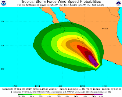
Tropical Storm Beatriz Strengthens in the Eastern Pacific

The second named storm of the Hurricane season in the Eastern North Pacific. A Hurricane Warning has been issued for the western coast of Mexico from Zihuatanejo northwestward to La Fortuna as Beatriz is expected to strengthen to hurricane status later today. The center of Beatriz is expected to approach the coast within the Hurricane Warning area tonight or early Tuesday. 


NOAA Satellite Image:


The Predicted Storm Path:


Cloud Top Heights:


Saturday 11 June 2011

Hurricane Adrian the first of the Pacific Hurricane Season

Hello everyone!
Sorry for the long wait, was out of town for a while and didn't have internet access. Anyhow, not quite finished with the Tornado Outbreak Blog. Should be out by next week. 


A little bit on a different note now, Hurricane Adrian formed on June 9, 2011 and intensified later that day into a Category 4 Hurricane. As a Category 4 hurricane, Adrian reached sustained winds of 137 mph (220 km/h) off the west coast of Mexico. Conditions were  favorable for further strengthening in the next 24 hours before the storm was to be affected by stable air and cooler waters. Adrian  posed no problems for land as it veered west northwest. This image was taken by GOES-13 on June 9, 2011 at 1345Z.


If you would like to know more about the storm timescale, visit http://en.wikipedia.org/wiki/2011_Pacific_hurricane_season#Hurricane_Adrian

Friday 27 May 2011

Jet Stream and Intro to Jet Streak Dynamics

Hey everyone!
Sorry for the long wait but here it is, the Jet Stream. Unfortunately, this will have to be a short blog, since I don't have much free time. Anyhow, jet streak dynamics is an interesting weather phenomenon that is being studied today. The jet stream plays a big role in the development of storms. Below is an expanded explanation about the role of the jet stream and what jet streaks really are.


As well below is the US-NAM 500mb model from 00Z, Saturday May 28, 2011 to 12Z, Sunday May 29, 2011. Notice that on the 12Z, Sunday May 29, 2011 NAM model we can see a trough over South Central California and Western Nevada.  This area is associated with having the maximum winds found in the jet stream. So keeping this in mind, a new low pressure system might bring some new storms into Monday, but some more analysis (for another blog) needs to be done to determine storm development and intensity.


My next blog will deal with the tornado outbreaks that have ravaged  parts of Oklahoma and Missouri, including some explanations on thunderstorm and tornado development, so stay tuned!

Saturday 21 May 2011

Intro to Primitive Equations

So I was thinking that a little review of the weather dynamics might help some of us understand it better, including myself, so here is some good old math for ya.


Also, I will include the derivations for the third thermodynamic equation.


In my next post I would like to introduce some simple Jet Streak Dynamics, as it is an application of  the Horizontal Momentum Equation. Till then, enjoy the Long Weekend!

Friday 20 May 2011

Interesting Development Today

Some interesting development has been going on in Oklahoma, Arkansas, and Eastern Texas today. As I wright, a strong line of thunderstorms is making its way through Little Rock AR and all the way South to Austin TX. As of  05/21/2011 00 UTC, here are two soundings showing a decent possibility for tornado producing storms. So keep on the lookout!


Here's the one for Little Rock AR:


The second one for Shreveport LA:


Tuesday 17 May 2011

Update

I've added some useful weather data links as well as some other fun blogs worth checking out!
 Also I saw an interesting animation on msnbc.com about last months Tornado Outbreak, so check it out via  http://www.msnbc.msn.com/id/42803576/ns/weather/t/watch-track-devastating-storms-southeast/from/toolbar
That will be all for now.

Welcome Weather Enthusiasts

My name is Martin Lach and I am currently a Toronto York University student going into my 3rd year in the Atmospheric Science Program. To keep things short, I'm working on a new blog that will cover some more complex weather phenomenon in more simpler terms. Also, I will provide a day to day analysis on the current weather across North America. That's all for now. Hope you all enjoy my next post.