
Here is a quick, but useful, guide to understanding a little more about our day to day thunderstorms.
Thunderstorm (Defn.):

1. One or more sudden electrical discharges occur.
- Lightning Flash
- Sharp rumbling - thunder
3. The cloud top temperature is less than -20˚C.

- Glaciated Tops
- Precipitation
The life cycle of a single cell can be separated into three stages:
- Cumulus stage
- Mature stage
- Dissipating stage
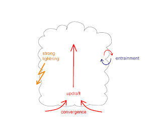
1. Cumulus Stage
Updraft:

2. Mature Stage

Updrafts continue...
Here Downdrafts are introduced:
Temperature
3. Dissipating Stage
Collapsing Cell

Downdraft

Severe Thunderstorm (Defn.):
Simply put it is a meteorological event consisting of a severe weather occurrence produced by a very large cumulonimbus cloud (CB).

Severe weather occurrence: If one or more of these occurs,
Updraft:
- Everywhere in the Cell
- Varies in space and time
- Maximal speed occurs at higher altitudes later in the period.
- There is Horizontal Convergence at all levels.
Temperature
- The cell temperature exceeds the environmental temperature at each level.
- As well, there are temperature anomalies in the updraft. Maximum usually occurs at end of the cumulus stage.

Precipitation
- Greatest concentration is above the freezing level.
- However, no surface precipitation.
2. Mature Stage

Updrafts continue...
Here Downdrafts are introduced:
- Initiated at mid-levels of the storm
- They increase in space and time
- Maximum downdraft winds in falling precipitation (rain, hail)
- Strong horizontal divergence at the surface ( Gusts can exceed 60 km/h)
- Reaches maximum height in the mature stage
 |
| ← Storm Motion |
Temperature
- Cloud tops < -40°C
- Cold anomalies in downdrafts (Max at low levels)
- Warm anomalies in the updrafts
- Ice crystals present at the cloud top
- Low level precipitation (liquid rain and solid (hail) possible)
- The precipitation horizontal boundary marks the downdraft boundary
- Hail possible in the downdrafts
3. Dissipating Stage
Collapsing Cell

Downdraft
- Spreads throughout the entire cell
- Speeds are less than in the mature stage
- Surface wind divergence rapidly decreases
- The turbulence intensity diminishes in the cell
- Cell temperature falls below the environmental temperature at each level and eventually equalizes
- The cirrus clouds blow off the top
- Shower activity becomes light and decreases in intensity

Simply put it is a meteorological event consisting of a severe weather occurrence produced by a very large cumulonimbus cloud (CB).

The diagram above (which is adapted from Browning et al., 1976; The different greyshades represent radar reflectivities of 35, 45 and 50 dBz) shows a typical cross section through a Multi-Cell Thunderstorm. There are four successive cells in different stages of development, each of which takes ~15 minutes:
- The shelf cloud n+1 has a, crisp, flat base which indicates an active updraft ahead of the cell n.
- Cell n is a daughter cell which is in a developing stage.
- Cell n-1 is in its mature stage and forms at the center of the storm.
- Finally, Cell n-2 is in its dissipating stage.
Severe weather occurrence: If one or more of these occurs,
- Wind Gusts → 90 km/h or more
- Hail → 2 cm in diameter or greater
- Rainfall → 50 mm in an hour or less
- Tornado
- Becomes very well organized with the surrounding environment
- The dissipating stage is in this case postponed
- Updraft and downdraft work independently and lead to longer storm life
- It is tilted
- Precipitation particles carried out which initiate a separate downdraft


