NOAA Storm Prediction Center

Wednesday 29 June 2011

Tropical Storm Arlene forms in the Gulf of Mexico


Tropical Storm Arlene formed in the southwestern Gulf of Mexico on Tuesday, making it the first named storm of the Atlantic season. The U.S. National Hurricane Center expects Arlene to strengthen before making landfall on Thursday.
A tropical storm warning has been issued for the coast of northeastern Mexico from Barra de Nautla northward to Bahia Algodones. Up to 200 mm of rain could fall over the Mexican states of Tamaulipas and Veracruz, with locally higher amounts possible over mountainous terrain.
Authorities warn of life-threatening flash floods and mudslides with these heavy downpours.

     
1. Satellite Image


 2. Cloud Top Heights


    3. Storm Track 


    4. Wind Speed Prob.


Monday 20 June 2011

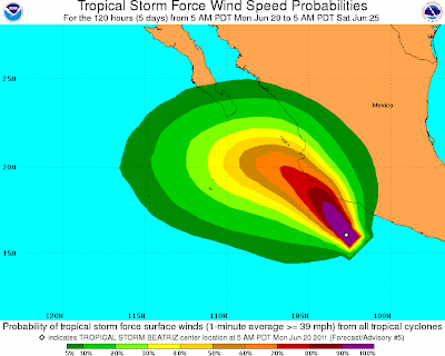
Tropical Storm Beatriz Strengthens in the Eastern Pacific

The second named storm of the Hurricane season in the Eastern North Pacific. A Hurricane Warning has been issued for the western coast of Mexico from Zihuatanejo northwestward to La Fortuna as Beatriz is expected to strengthen to hurricane status later today. The center of Beatriz is expected to approach the coast within the Hurricane Warning area tonight or early Tuesday. 


NOAA Satellite Image:


The Predicted Storm Path:


Cloud Top Heights:


Saturday 11 June 2011

Hurricane Adrian the first of the Pacific Hurricane Season

Hello everyone!
Sorry for the long wait, was out of town for a while and didn't have internet access. Anyhow, not quite finished with the Tornado Outbreak Blog. Should be out by next week. 


A little bit on a different note now, Hurricane Adrian formed on June 9, 2011 and intensified later that day into a Category 4 Hurricane. As a Category 4 hurricane, Adrian reached sustained winds of 137 mph (220 km/h) off the west coast of Mexico. Conditions were  favorable for further strengthening in the next 24 hours before the storm was to be affected by stable air and cooler waters. Adrian  posed no problems for land as it veered west northwest. This image was taken by GOES-13 on June 9, 2011 at 1345Z.


If you would like to know more about the storm timescale, visit http://en.wikipedia.org/wiki/2011_Pacific_hurricane_season#Hurricane_Adrian