
A possible severe weather outbreak in parts of Europe has caught my eye, so I thought I would write a brief discussion on what to expect. Below is the surface pressure map from Met Office for 12Z tomorrow, indicating the surface low pressure and frontal boundaries.

The Adriatic Sea and its surrounding areas are the most likely to experience the largest impacts from this outbreak. All types of severe weather can be expected, however locally heavy/excessive rainfall will be the greatest threat due to the slow moving nature of an upper level low.
A powerful upper level low will be moving across the central Mediterranean and serve as a focus for more robust severe weather. Another trough will be pushing east across NW. Europe with an associated frontal boundary from central Scandinavia into central Europe. A short-wave will move from E. Scandinavia into NW. Russia.

I'm looking at a HIGHER Risk for coastal areas of the Adriatic sea inland into western Balkans and into parts of N. Italy, with the threat for excessive rainfall, tornadoes/waterspouts and to a lesser extent for severe winds and large hail. It appears likely that a severe weather outbreak will occur on Wednesday and locally dangerous flooding conditions are expected. As the upper low makes progress further SE into the central Mediterranean, widespread storms and clusters could develop/maintain themselves along the SE-wards moving cold front across E. Adriatic sea onshore onto the mountain range.
Strong QG forcing combined with a highly unstable airmass: 2000-2500 J/kg of CAPE and moderately strong 0-6 km shear: 20-25 kts within a persistently strong southerly LLJ should result in organized severe storms where a serious flash flood risk will exist due to combined strong orographic and convective rainfall. Further north towards N Italy, a stalled frontal boundary should act as a trigger for the development and persistence of clusters and therefore high amounts of rainfall are expected as well.
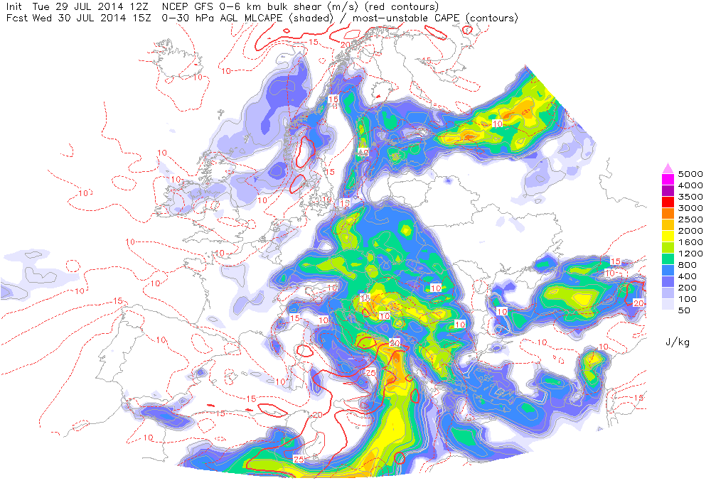

I'm also looking at a MODERATE Risk for E. Germany, the Czech Republic, W. Poland into the Baltic sea and SE. Sweden with the threat for mainly excessive rainfall. An eastwards progressing slow moving frontal boundary should result in widespread and mostly multi-cell storms in a strongly unstable but weakly sheared environment: 1000-1500 J/kg of CAPE with less than 10 kts of 0-6 km wind shear. As well, the Boundary Layer (BL) moisture is showing mixing ratios between 12 and 14 g/kg and dewpoints between 17 and 20 degrees C, making the airmass rich in moisture during cell development.

Below are the ESTOFEX GFS model maps, the WRF 13 km Europe model, and MeteoNetwork GFS models that illustrate tomorrow's severe potential. A couple of things to note is the strong southerly LLJ of 15-20 kts, which will be providing large amounts of moisture, as shown below. We can also see that for Central Europe and for the eastern parts of Germany, the upper level winds are weak, which will lead in cell training and therefore the flood potential. The reason I did not emphasize as largely on the tornado threat is due to the lack of 0-3 km Storm Relative Helicity (SRH) for parts of Central Europe. However, a tornado/waterspout cannot be ruled out in Northern parts of Italy, were 0-3 km SRH values are exceeding the 200 m2/s2 mark.


