Since I've been largely focused on Europe lately, I taught I'd continue with an interesting and potentially severe setup that will unfold in central Europe later in the day tomorrow. Below is the surface pressure map from Met Office for 12Z Tuesday and 00Z Wednesday, indicating the surface low pressure and frontal boundary crossing Europe tomorrow.


An extensive ridge across South-Central Europe will be interrupted by a strong trough from western Europe which will advance easterly towards the Benelux region in the afternoon tomorrow. This will provide large scale ascent for widespread storm initiation along the eastwards moving cold front. Current models show strong instability overlapping with moderate speed and directional shear. This would prove sufficient enough for rapid storm initiation, with a well organized environment for supercell storm development.
Until the evening, storms should remain discrete and bring large hail, very strong winds and the possibility of a tornado, while towards the evening hours storms should merge into a large cluster or two spreading towards southwest Poland and the Czech Republic bringing heavy downpours.
The areas of greatest interest to me, as shown above, will be parts of eastern France, central Germany and western Czech Republic where widespread severe storms with large hail, powerful winds, heavy rainfall and the formation of tornadoes, is increasingly likely to form ahead and along the eastwards moving cold front from mid afternoon into the late evening hours.
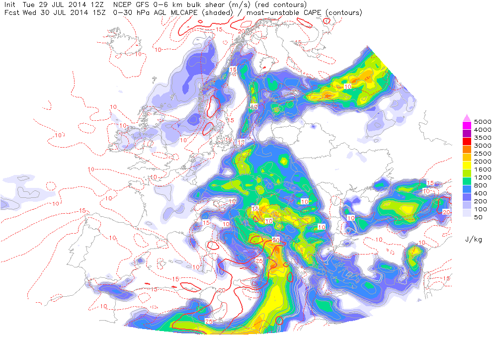
Strong QG forcing combined with a very unstable airmass: 2000-2500 J/kg of CAPE and very strong 0-6 km shear: 15-25 m/s within a persistently strong southwesterly LLJ: 15-20 kts should result in organized convection, including supercells and QLCS.
Below are the ESTOFEX GFS model and the WRF 13 km Europe model outputs from Keraunos, that further illustrate tomorrow's severe potential. The image below depicts a strong jet in place for tomorrow afternoon, where the area of divergence aloft will favour storm development from eastern France to western Czech Republic.
The Boundary Layer (BL) moisture is showing mixing ratios between 11 and 13 g/kg and dewpoints between 16 and 22 degrees C, making the airmass rich in moisture during cell development. A couple of things to note is the southwesterly low-level jet (LLJ), which will be pushing large amounts of moisture northward. As a linear line of storms emerges into the evening hours, excessive amounts of rainfall will become the greater threat. The greatest tornado threat lies in southern parts of Germany and Eastern France were the 0-3 km Storm Relative Helicity (SRH) is the highest.


Below are GFS model soundings for tomorrow afternoon. Both are depicting a very unstable airmass right from the morning to the afternoon. Given that the morning soundings showed large CAPE and no capping at the surface, leads me to believe that the afternoon CAPE values generated by the GFS model are being exaggerated. If storm initiation begins earlier in the day, less CAPE buildup will take place in the afternoon hours. Just something to keep in mind!


